Published 2025-08-29
Drone technology is transforming how professionals collect spatial data across engineering, construction, mining, and environmental industries. At Geographic Solutions, we provide both LiDAR (Light Detection and Ranging) mapping and photogrammetry mapping services throughout Washington and the Pacific Northwest.
If you’re considering drone mapping for your project, understanding the differences between LiDAR and photogrammetry is essential. Each method offers unique advantages depending on site conditions, accuracy requirements, and project goals. This guide breaks down how they work, when to use them, and how they can help you save time and money.
What is Photogrammetry?
Photogrammetry uses high-resolution drone imagery to create 2D maps and 3D models. By capturing overlapping photos from multiple angles and processing them with specialized software, we generate detailed surface models of your site.
Strengths of Photogrammetry
- Cost-effective: More affordable than LiDAR, making it ideal for routine mapping or projects with limited budgets.
- High-resolution visuals: Produces photo-realistic 3D models and orthomosaic maps, perfect for planning, design, and presentations.
- Versatile applications: Stockpile measurement, construction progress monitoring, site inspections, and marketing visuals.
- Great for exposed surfaces: Best suited for open landscapes, quarries, construction sites, and stockpiles without heavy tree cover.
What is LiDAR?
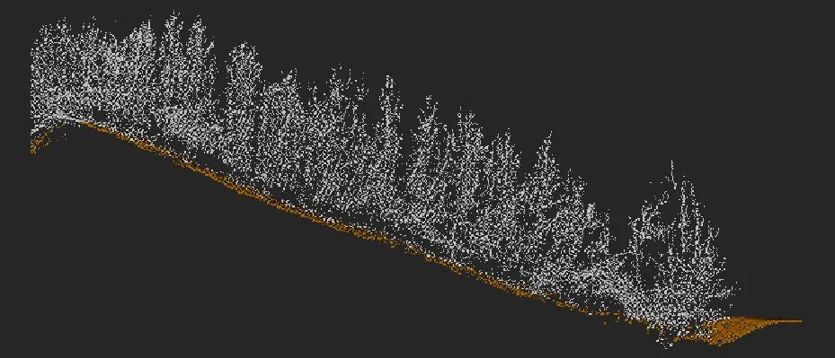
LiDAR (Light Detection and Ranging) uses laser pulses emitted from a drone-mounted sensor to measure distances. Millions of points are recorded per second, generating a dense 3D point cloud that captures fine details of terrain and structures.
Strengths of LiDAR
- Vegetation penetration: Accurately maps bare earth terrain beneath trees and brush.
- High accuracy: Elevation data can be accurate to within a few centimeters — ideal for engineering and permitting.
- Detailed topography: Creates precise contours and digital terrain models for design, hydrology, and infrastructure projects.
- Reliable in complex terrain: Works in steep, uneven, or inaccessible areas where traditional surveys are costly.
Limitations
LiDAR requires advanced sensors and processing, which increases cost compared to photogrammetry. It also produces less photo-realistic imagery — excellent for engineering, but less effective for client-facing visuals.
LiDAR vs. Photogrammetry: Which is Right for Your Project?
Both methods are powerful, but each has ideal use cases. At Geographic Solutions, we guide clients toward the best approach based on project needs.
Choose Photogrammetry when:
- You need cost-effective aerial mapping.
- Stockpile measurement, construction progress, or inspection is the main goal.
- Visual presentation is just as important as data accuracy.
- Your site has minimal vegetation and clear surface visibility.
Choose LiDAR when:
- You need precise elevation data for engineering or permitting.
- Your site has dense vegetation or rugged terrain.
- You require bare earth models for stormwater, hydrology, or floodplain analysis.
- Accuracy is critical for design work or regulatory submissions.
In many projects, we combine both methods — LiDAR for ground-truth elevation data and photogrammetry for high-resolution visuals. This hybrid approach delivers the most complete dataset.
Real-World Applications in Washington
Our clients across Washington and the Pacific Northwest use drone mapping for a wide range of industries:
- Mining & Aggregates: Stockpile measurement, pit progression mapping, and reclamation planning.
- Construction & Engineering: Pre-construction surveys, grading verification, and as-built documentation.
- Environmental & Permitting: Wetland delineation, stormwater pond design, and compliance reporting.
- Forestry & Land Management: Bare earth topography beneath canopy cover.
- Utilities & Infrastructure: Corridor mapping for roads, pipelines, and transmission lines.
With both LiDAR mapping services and photogrammetry services, Geographic Solutions delivers the right solution no matter your industry.
Why Work with Geographic Solutions?
Choosing the right mapping technology is just one part of the equation. Equally important is having a local partner who understands your industry, regulatory environment, and project needs.
At Geographic Solutions:
- We provide drone mapping across Washington and the Pacific Northwest.
- We combine LiDAR and photogrammetry to ensure the best fit for your site.
- We specialize in industries where accuracy and compliance are critical, including mining, construction, and environmental permitting.
- Our team delivers data you can trust — with the professional reports, maps, and models your project requires.
Whether you’re an engineer in Seattle, a contractor in Tacoma, or a land manager in Spokane, Geographic Solutions provides professional drone mapping services in Washington and the Pacific Northwest.
Contact us today to learn whether LiDAR mapping or photogrammetry mapping is right for your project.
How Geographic Solutions can help
Geographic Solutions supports aggregate operators, landowners, contractors, and investors with permitting, mapping, reserve modeling, market studies, valuation, and due diligence for pits and quarries in Washington and Oregon.